|
12/14/2020 0 Comments First 3 days: A Trial by FireBecause of some neighbors being very “awake”, even after quiet hours, we couldn’t fall asleep. At our supposedly 1am wake up call, I decided to give us a bit more time and we finally woke up at 3am, after a miserable night. I could see that Damien was upset. He barely touched his breakfast, and it got me worried, especially knowing what would come on Day 1. But I didn’t say anything and at 4am, we were out of the door, backpacks and headlamps on, ready to walk along the Happy Isle loop road to the official start of the John Muir Trail. The air was warm and with no soul in sight, it was an eerily moment for both of us. After 15min, we were standing in front of the High Sierra Loop Trail sign, with the distance of 211 miles listed at the bottom. After some obligatory pictures, we finally set foot on the JMT, with the goal of going all the way to Mt Whitney.
The first 2 miles to the top of Vernal Fall are pretty brutal, especially with a 30 pounds backpack. We took our first rest there and Damien tried to eat something but threw it up immediately. He was really anxious and I did my best to reassure him that it would be better later in the day. We had planned and were very excited to climb Half Dome at sunrise, which was included in our permit. However, with our late start and Damien not feeling well, I decided after a few more miles not to do it. It was an easy decision and he felt more relaxed afterwards. When we got to the HD trailhead at mile 5.6, I called my wife Anne-Cecile to give her an update and she too was happy about the new plan. That would be our last phone call for a while. Then we charged on with renewed energy, full daylight now and a chance to be ahead of our planned schedule. By the end of Day 1, instead of stopping at Sunrise High Sierra Camp at mile 12.6, we stopped at Cathedral Lake at mile 16.6. We immediately took a dip in the lake and really enjoyed the sunset surrounded by mountains. Then setting up camp for the first time and doing all the chores of unpacking everything, preparing dinner, and getting ready for the night while being tired was not so fun. We were not used to the outdoor life just yet and it showed! I knew that it would take time for us to feel comfortable on the trail and that the first 3-4 days would be critical to our success… or failure. Day 2 was much better though. After our breakfast with a view, we broke camp and started hiking around 7am. We were already close to 10,000 feet in elevation, having gained 6,000 feet on Day 1. The plan for the day was to go over the first pass of JMT, Donohue at 11,000 feet, but it would mean a 20+ miles day. We were confident about it as we passed many hikers and we also didn’t have any issues. We took a nice break in the afternoon along the Lyell fork, at the bottom of Donohue, and chatted briefly with a couple who showed us their portable hot shower! Very cool but way too heavy for us. We then started the climb and went over it 1hr before sunset. We witnessed an amazing view from the top! On the way down, we met a girl who was going the opposite direction as us. As it turns out, she was 900 miles into the Pacific Crest Trail, all alone, and was hiking in crocs because her hiking shoes were destroyed. She saved money for years in order to do PCT and was obviously living the dream. And we thought we were badass. Now this is next level! Her trail name is Toad and we both hope that she was able to complete her journey. After leaving her, we were in complete awe and it gave us a new perspective of our “little” adventure. After a few more miles, we stopped near Rush Creek Trail, having done 21 miles for the day. Setting up camp was faster this time, mainly because of many bugs killing us. Day 3 was our lucky day. The plan was to hike 18 miles to Red’s meadows, the site of our first resupply. The terrain was mainly flat for the day and then downhill to Red’s. Days before our trip, I called Red’s meadows and tried to book a cabin for the night. Everything was fully booked but the lady told me to try everyday as there might be some cancellation. After several more failed attempts, I lost hope and thought we’d be sleeping in our tent. Then, after we passed Rosalie Lake, we saw several hikers talking on their phone. There was a strong signal right there. We stopped, called home and then Damien told me to try again to call Red’s. I called without much hope but there was one cabin available! I booked it on the spot. We both were so happy because we started to feel pain in the shoulders, back, and we needed a big burger and a hot shower so bad! On the way to Red’s, we couldn’t stop thinking about a huge burger and fries, being already tired of our dried food. We arrived a few hours later, checked in and I asked when the Mule House Café would close. She said it has closed 1 minute ago! It was 6:01pm. She immediately saw our distress, went over there and convinced the chef to reopen the grill for us. Those were the best burgers ever! The day was saved not once but twice, and now after a real meal, a hot shower and the comfort of a cabin, we could finally relax. The first 3 days were very tough, emotionally and physically. We had hiked 56 miles and gained a lot more experience in the process. Damien was much more confident now and I felt strong. We knew intuitively that we had broken a mental barrier and now, unless some physical issue, we would finish the JMT.
0 Comments
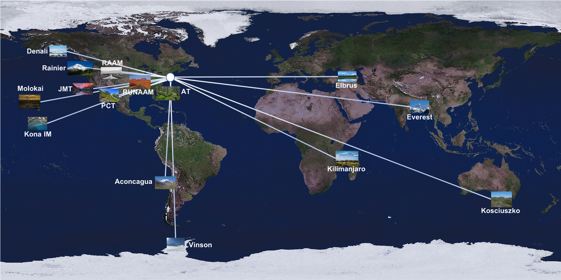
12/2/2020 0 Comments Time to get back on the horse!It’s July 30th, 2020 and my son Damien and I are about to embark on a flight to Fresno, CA for the beginning of our JMT journey. It has been a long process for him, after finding out about JMT on a google search in 2016 during his French(!) class in 10th grade, and a frustrating wait for me after my bike accident in 2017. I had recovered pretty quickly at first, but each time I would start training, whether swimming, biking or running, I would develop nagging pain that would last weeks. My training was basically stop and go for almost 3 years. I even attempted (and finished!) the IronMan triathlon in Texas in April 2019, but I had to walk the entire marathon.
When my plan to do IM Texas again was scratched in 2020 due to Covid-related cancellation, and we decided to postpone our Kilimanjaro trip in the summer, I applied for a JMT permit in February and got a few weeks later the highly coveted reservation to hike the John Muir Trail from Happy Isle in Yosemite to Mt Whitney. Finally, he and I had a big goal in front of us, despite this weird Covid lockdown life. We immediately started training, buying all the hiking gears and gathering as much info as possible. When Yosemite NP reopened mid-June and I was able to rearrange our ever-changing travel plans, we knew that JMT was a go and that I would finally get back on that horse, chasing dreams on my bucket list. Touching down in Fresno, CA was anticlimactic. The airport was basically empty, all restaurants and stores closed and we were only 3 people in the big YARTS bus going from Fresno airport to Yosemite Village. However, our mood changed dramatically when we saw El Capitan upon exiting the Wawona tunnel. What a magnificent view! Upon arrival to Yosemite village and after taking it all in for a few minutes, we walked to the Curry village and checked-in for the next 2 nights. It has been a long travel day, but at least it went flawless. We needed a good rest for our JMT warm up hike planned the next day. The year before, my daughter Estelle, Damien and I were supposed to hike up El Capitan, but there was still lots of snow on the trail in early May, and we decided to turn back at Upper Yosemite Falls. Snow was obviously not an issue this year, but rather the heat. It was a very hot day and, when combined with travel fatigue, 17 miles of hiking and 5,500 feet of elevation, it made for a brutal warm up hike. However, when we stood on top of El Cap, gazed at Half Dome and then look down at Yosemite Valley, it was all worth it. Looking at an anchor at the edge, Damien and I could not believe that few people could climb it with just their hands and feet and a rope for safety, and one special human, Alex “no big deal” Honnold, doesn’t even need a rope! It would have been fun to rappel down El Capitan but we’re not Honnold or Caldwell, just day hikers at this point. We haven’t even spent one night in a tent prior to this trip. So, we safely hiked down Yosemite Falls trail in the afternoon heat, and we were absolutely cooked when we reached the village. We immediately went to the Village Store, bought last minute gear/food we needed, and walked back to our little cabin. After dinner, we emptied our backpacks, reorganized our 2 Bear Vault (BV500) food canisters and prepared everything for our planned 2am start. We were both excited and nervous at the same time. In a few hours, we would launch into the unknown, and although we both were very fit, JMT is a long hike and many things can go wrong. The 1st day would be a pretty tough one and we needed as much sleep time as possible. We went to bed around 8pm, hoping for a good 5hr sleep. 7/16/2017 1 Comment First bump on the roadSunday July 9th was a gorgeous day, not a cloud in the sky and the perfect temperature. I decided to go for a long training ride and left home at 7am. After 5 solid hours and 100 miles, I was riding back home on the outskirts of Belmont, MA. I was going downhill, just 5 minutes from home, cruising at around 25mph when a car going the opposite direction, suddenly turned left in front of me and cut me off. I was probably no more than 2 seconds away from impact, and there was no way to avoid him. In those 2 seconds, I knew my life was about to change and I was just hoping that it wouldn’t be for the worst.
After Mount Rainier last May, I had already planned adventure #3. Last year, I did Mont Tremblant Ironman Triathlon in Quebec to try to qualify for the Kona Ironman. However, I couldn’t run during the marathon, as I was still plagued with severe calf cramping. Soon after, I registered for Mont Tremblant IM again in 2017. During the winter and spring, I maintained a good level of training in swimming and biking, and tried to incorporate more running as it is my weakest specialty by far. With Mount Rainier behind me, I increased the swimming and biking, while still being careful to not get injured while running. Everything was going smoothly and I was hopeful that this year would be the year I could qualify again for the Kona Ironman, 25 years after my first Kona experience back in 1992. But, things don’t always go the way we want them to. The hit was violent, as I didn’t have time to brake. I flipped over the car and while airborne, I was able to see the windshield completely smashed. When I hit the ground, everything stopped. I never lost consciousness and soon after, the pain started. I couldn’t move my left leg and I couldn’t breathe. However, I was immediately able to move my fingers, toes and neck. That’s what 15 years of working in a Para- and Quadriplegic clinic had taught me. I was not paralyzed. Once at the hospital, they found that I had a broken femur, 4 broken ribs, a small pneumothorax and bruises all over. I had surgery the next day and after several days at the hospital, I was finally able to go back home. Physical therapy has already started. I know it’s going to be a long road to recovery but I hope to be back to 100% in a few months. I would like to thank all the first responders (EMTs, firefighters and police officers) as well as the people on the scene of the accident that helped me tremendously. A big thanks also goes to the personnel (ED, surgeon, trauma, cardiology and radiology teams and all the nurses of the SICU and 6th East floor) of The Lahey Clinic in Burlington, MA. Finally, I would like to express my absolute love for my family. Damien was shaken but took it in stride. Estelle immediately drove up from NYC and spent the next 5 days in the hospital, putting into practice what she has learned at Columbia Nursing School. Anne-Cecile was terrified when she received that phone call that no one wants to ever receive, but she was as strong as one could possibly be under the circumstances. Now that I write this, we are all doing fine and looking forward for better days to come. 6/9/2017 0 Comments Rainier: The Climb, Part 3We started the descent with only 10 feet of visibility, but the wind wasn’t very strong and it wasn’t too cold. The guides told us that we would only take 2 breaks on the descent, one on top of the Disappointment Cleaver at 12,500 feet and one at the Flats at 11,200 feet. After the crevasse incident, we were all very careful and made sure to follow the same exact path as the person ahead of us. We made good time and after 1hr30’, we finished climbing down the area with the biggest crevasses and took our first break. Finally, the sky cleared and it was sunny again. I enjoyed another beautiful view of the mountain with peace of mind, knowing that I had made it to the top and the most dangerous part was almost over. We resumed our descent but as we were slowly descending the Disappointment glacier using a switchback pattern, I suddenly heard someone down the slope screaming: “Rocks!” Immediately our guides yelled: “Look up!” We all looked at the upper part of the glacier and saw dozens of ice blocks coming directly at us like a freight train. A cornice up high had just collapsed and released blocks of ice, some as big as truck tires. Luckily, we could see the whole glacier and had time to estimate the direction of the biggest blocks. Plus, we were not short-roped but had about 40 feet interval between climbers. That gave us plenty of room to maneuver and avoid being hit. It was unreal to see the biggest blocks zooming by in-between us at high speed. The whole experience probably lasted less than a minute but it felt like we were in slow motion. No one was seriously injured and after we calmed our nerves and regrouped, we kept climbing down, hoping that Rainier would just let us finish our adventure without any more surprises. Jess told me that we would basically be safe once we got to the Flats. I couldn’t wait to get there and finally relax some 11 hours after we started our journey to the summit. Once there, we sat on our backpacks, ate and drank whatever we had left, and talked about the incident. Chris, one of the clients, was “unhappy” that I didn’t turn my GoPro on to shoot the icefall. He had a point, I said, as it would have been amazing footage to add to our little home video of our adventure.
After our last break on the upper mountain, the last stretch from the Ingraham Flats to Camp Muir went by really fast and we were surprised and very happy to have all the other clients who didn’t summit waiting for us for a wonderful homecoming celebration at Muir. There, we had an hour rest where we had to repack our backpacks with all the stuff (sleeping bag, trash) we didn’t bring to the summit, ate all that was left (which was very little for me), and got ready for the climb down to Paradise, where the bus would wait for us to drive back to Ashford. We were all ready in 30 minutes, very much looking forward to be off the mountain. The snow was deep and it wasn’t an easy walk down but It took us less than 2 hours to finally be off the snow and in the parking lot of Paradise. I hit the stop button of the GPS tracking device one last time to let my family know that I was done with the climb. We had a group photo with Mount Rainier in the background, climbed into the bus and drove away from the mountain that had been our home for the last three days. At the RMI headquarter in Ashford, WA, we had a small celebration with pizzas and beer with the guides. They presented each of us with a certificate for summiting Mount Rainier* and some very nice words about our successful climb despite many challenges. I cannot express my gratitude enough to Solveig, Jess and JM, the guides in our group, as well as Brent, our lead guide. They did an amazing job; teaching us the basics of mountaineering, guiding us safely to the top of Rainier and back to basecamp, with many fun times but always with a “safety first” mantra in their mind. After the crevasse and the icefall incidents, our story could have been written very differently, if not for the RMI guides’ skills and professionalism. I’d also like to thank my fellow climbers - we’ve all shared something special together and although we might not see each other ever again, the bond will always remain. I personally learned so much throughout these five days that I can’t even begin to detail all of it. It was my first ever climb on a real glacier and it was also the first climb of the season for RMI. I don’t know if Mount Rainier decided to put on a show for us, but what a climb it was! From climbing up a glacier in the middle of the night, to witnessing a gorgeous sunrise, to experiencing the dangers of the mountain, and to rely on each other’s strength while on a rope, I saw first hand both the “good” and the “bad” part of mountain climbing, thankfully without experiencing the “ugly” of it. Despite my lack of expertise and my being uncomfortable and, frankly, scared, I slowly gained confidence on the mountain and really enjoyed the summit day. It showed me that, although I still have a long way to go before climbing bigger mountains, I think these five days on Rainier were a success and gave me a “go-ahead” signal to try to tackle the other mountains on my dream list. 2 down, 13 to go! Summit of Mount Rainier*: Most of the time, people who reach the crater rim of Rainier are considered having summited the mountain. However, the true summit is called the Columbia Crest, a mere 200 vertical feet higher than the crater. It would have taken us 45 minutes to go there and back to really tag the top of Rainier. Circumstances (crevasse incident and weather going bad) led our guides to call it a day and not go for the true summit. Honestly, the other clients and I were content with stopping our climb at the crater, and get back down as soon as possible. This climb was full of uncertainty and being there at the crater was a big achievement for all of us. However, I personally considered having climbed “only” 99% of Rainier. That’s why I added an asterisk to the Rainier page title. I hope that I will have an opportunity in the future to do an expedition skills seminar on Rainier with RMI before the bigger mountains on my list, so that I can climb that last 1%. 5/31/2017 0 Comments Rainier: The climb, Part 2It was windy and the flapping of the tent kept me awake most of the night. It was a relief when Solveig woke us up at midnight. Finally, summit day has arrived and I could not be more excited, yet nervous at the same time. In 1 hour, we were all roped up, crampons on and ready to go. We started the same route we took the day prior, but this time it was in the middle of the night. Seeing all the headlamps forming a line on the Cowlitz Glacier was completely surreal. I had a big smile on my face since I knew the route was easy and that I could relax and enjoy the moment. After 1hr20’, we took our first break at the Flats. This is where several clients decided to stop their attempt. It’s never an easy decision but knowing your limits and making the best and safest choice for your own good is remarkable. Then, we resumed our climb on a direct route up the Ingraham Glacier. The usual route turns right to the Disappointment Cleaver but Brent told us that the risk of icefall or rocks was too great. A team of guides from RMI prepped our route the day before and told us that it was safer to go the more direct way. After Jess gave me a “warning” during this 2nd section, we arrived at the upper part of the Disappointment Cleaver at about 12,300 feet and we took our second break. It was around 3:30am. This section was very steep and I started to feel the altitude. I was last on my rope team and had to constantly monitor the distance between Barton, the teammate in front of me, and I. It was not a smooth walk and I was out of breath every time I had to increase the pace. However, I recovered quickly and was reassured. Out of the eight remaining clients, one decided to turn around. Before starting up again, Brent and Solveig told us that from now on, we had to be fully committed to summiting because it would be too complicated to turn around later on, as we did not have enough guides to babysit us on our way down. The 3rd section was not very steep and we were climbing very well. We started to see some crevasses along the way. At first, there were small but as we climbed up, they started to get bigger and bigger. At some point, I found myself crossing a crevasse on a small ladder. They weren’t like the big ladders on the Khumbu Icefall on Everest, but it was still pretty cool. The sun gradually rose and gave us a completely different view of our surroundings. A sunrise while climbing up a mountain glacier is a truly majestic experience. That single moment was one of the best of the entire climb, except for maybe the summit. Soon after, we stopped for our last break before the summit push. It was 5am and we were at the “High Break” at 13,500 feet. Brent and Solveig told us the day before that the last section would again be very steep but shorter than the previous ones. We were all psyched up about getting to the top. The sun was shining, the wind was minimal, and we were less than 900 vertical feet from the summit, all still going strong. Well, Mount Rainier had other plans for us.
As we were slowly ascending through a maze of crevasses and closing in on the crater of Rainier, I heard someone yell: “falling!” I saw one of the clients, just 3 spots ahead of me, being pulled forward very rapidly. He then stopped abruptly on the ground. Everyone just froze in place, anxious to hear from Solveig. After a few minutes, she told us that Brent, our lead guide, just broke through the snow over a crevasse and fell in about 10 feet. Eight climbers from another group had just crossed this snow bridge without any problems. He was apparently uninjured and Solveig has already started the process of rescuing him. It took her a good 30 to 45 minutes to get him out of the crevasse. During the rescue, the others and I were wondering if Brent was unhurt and what would happen next. “Was the climb over?” we all thought. We were amazed when, finally free from the crevasse, he told us with a big smile on his face to get ready for the summit. What a tough guide he is! We later learned that, in his 31 years of climbing, and after 518 summits of Mount Rainier, 2 Everest attempt (1 summit) and 23 Denali summits, among other climbs, he has never once fallen in a crevasse. We were all joking that if it had been us in the crevasse, we would have had to change our underwear, whereas for Brent it was like business as usual. We resumed our climb, relieved that it would just be a good story to tell, and hoping that it would be our first and last problem on the mountain. However, during our forced stop, the clouds built up near the top and the temperature dropped. It was not completely whiteout conditions but it became more challenging and uncertain. We were only now 30 minutes from the crater so I was confident that we would all make it. We had to take a small detour to avoid the now open crevasse and we all managed it like seasoned pros despite being in the steepest section of the entire climb. Finally, at 7am we entered the summit crater of Mount Rainier! We all cheered, high-fived and bear-hugged each other to celebrate our summit as much as to release the stress accumulated over the last 6 hours. Personally, it was an incredible and emotional moment. I had a tracking GPS device with me during the climb, where I had set up a message that could be sent via satellite to my wife and children. As soon as we entered the crater, I hit the button and I knew that they would receive the “summit message” within minutes. Somehow, they were with me on the summit, and it made this moment even more special. After getting some snacks and drink, we got ourselves ready for the descent. All the guides told us throughout this journey that getting to the top is only the half of the climb. Most accidents happen during the descent and that we should never become complacent or relax until we’re done with this dangerous part of the climb. We had no idea how right they would be.... 5/25/2017 0 Comments Rainier: The climb, Part 1“Patrick! You don’t want to tumble here”, says Jess, one of our guides, probably sensing that my footing was not great. It’s 3am on our summit day and we’ve already been climbing for 2 hours. The night is clear, thanks to a full moon, and windy but not overly cold. We are in the middle of the Ingraham glacier at about 12,000 feet in elevation, following a switchback pattern to ease the 45-degree slope of the headwall. I then looked down and realized that a misstep here could have very serious consequences, not only for me but for the 2 other members on my rope team. Welcome to Mount Rainier!
Two days earlier, we started the approach climb from Paradise (5,400 feet) to Camp Muir (10,080 feet), a 4,680 feet escalation that does not require any crampons or technical expertise. I was very excited to finally start my “climbing career”, but also anxious to see if I would like it and/or if I would be capable of getting to the summit. The first hour went by quickly but then we approached a somewhat steep slope on the Panorama face that leads to Panorama Point at 7,100 feet. I felt uneasy with the deep snow and the steepness of the face, in addition to a 40-pound backpack. Throughout this entire section, I was wondering if I was biting off more than I could chew. I breathed a sigh of relief when we arrived on top and took our first break. The view was absolutely incredible, which helped me relax a bit. After our 15-minute break, we started back up but this time on a gentler slope. I felt strong and confident as I could easily follow our guide Solveig’s pace and the other eight young clients in the group. Then, after a 6-hour approach and a final section up the Muir snowfield, we arrived at Camp Muir. There were several stone structures at either end of the saddle, one for the guides and clients and one for the public. These were very rustic accommodations, to say the least, but you can’t beat the view. From Camp Muir, you can see Mount Adams, Mount St. Helens, Mount Hood and the Tatoosh Range. I almost had to pinch myself to make sure it wasn’t a dream. But soon after, reality set in as the guides told us to rehydrate and eat plenty in order to get ready for the summit day. During our approach climb, Solveig asked us how we felt and if we wanted to go for the summit the next day. All nine of us replied, “Hell yeah!” Not only would the weather be perfect for a summit bid, but it would also decrease our total climb by two days, as we would go back and stay in Camp Muir directly after our summit attempt. We would then climb back down to Paradise on the last day. However, the other groups of nine clients were much more tired than us, and Brent, the leading guide, after checking the weather, decided to give them (and us) one rest day so that they have a better chance for the summit. Unfortunately, I don’t think there were enough guides to make two different summit attempts. If something went wrong, you would want to have a lot of manpower and dividing the guides into two groups would have been risky. I was a little disappointed but understood the reasoning. After the summit talk, we ate some more and prepared for the night. We were 18 people crammed in a bunkhouse, so you can imagine how interesting the night was. The next morning, we went up to the first section of the upper climb, as a practice run. We put crampons on, roped up and traversed the Cowlitz Glacier, climbed the Cathedral Gap and stopped at the Flats on the Ingraham Glacier at 11,200 feet. It was a gorgeous morning, sunny with no wind. It took us only a little more than an hour, and I felt good physically. As we were eating snacks and hanging out before going back to Camp Muir, I kept finding myself feeling amazed by the expansive view we had on this glorious day and couldn’t quite believe where I was, especially being a complete novice just 4 days ago. We were back at Camp Muir for lunch without any problems. In the afternoon, another client and I decided to move from the bunkhouse to a tent that was available to us. I wanted to have the full climbing experience, plus I probably wouldn’t sleep much anyway on the (short!) night before our summit attempt. Around 5pm, Brent and Solveig gave us the details of the summit climb and the route we would take. We were all listening carefully because, despite all of us being rookies, now we knew what was ahead of us and how serious of a mountain Mount Rainier really is. Several clients decided against doing the summit bid and others said they would try and see how they felt at the Ingraham Flats. Only nine or ten of us were fully committed to the climb. That evening, we went to bed around 5:30pm, anxiously awaiting the following day.... I arrived in Ashford WA last Friday, where most of the big names in mountaineering climbing have their headquarters. I have signed up with RMI Expeditions who was founded in 1969 by the twins Whittaker, Lou and Jim. Jim became the first American climber to summit Mt Everest in 1963. This year will be their 49th year running climbing seminar up to Mount Rainier. Most of the best American climbers in history have worked or still work at RMI as guides. So I knew that I would be in good company during this adventure and I would learn a lot from all the guides.
The next morning, I drove up to Paradise, our “launch site” for the climb. At the entrance of the National Park, there was no snow at all but as I approached Paradise, it started snowing heavily at times and there were big snow banks on each side of the road. Finally, the weather cleared and I arrived at the visitor center parking lot with literally walls of snow left and right. I couldn’t believe it but the mountains were so beautiful. I tried to see Rainier but it was a little cloudy. I started to climb up a little bit just to get my legs back and also to test my mountain boots. And after about 30’, I finally could see the top of Mount Rainier. Wow! It’s a massive mountain and completely covered with snow and ice from bottom to top. It will definitely be a full climbing experience. In the afternoon, I picked up all my rentals gear for the climb, and we had our orientation. Eighteen clients, mostly neophytes, have signed up for this 1st climb of the season, separated in 2 groups. As you can expect, we all come from different horizons and background but all the members seem to be fit and well prepared for the climb. You don’t improvise this kind of adventure. Our leading guide is Brent Okita, who has 516 summits of Rainier and the guide for my group is Solveig Waterfall who has 120 summits of Rainier. So they have accumulated a tremendous amount of expertise on this mountain and they are not shy of sharing it with us. Today was our first real day on the mountain, learning all the basic mountaineering safety and techniques that will help us get to the top. We put crampons on and went up and down the mountain, using different footing techniques depending on the steepness of the slope. We learned how to self arrest with an ice ax, whether solo or on a rope team. We also travelled up and down the mountain as a rope team. There are a lot of small details that you need to remember and obviously we don’t have yet the muscle memory or the experience to safely climb on our own. But that was a very good approach to what we will expect come the real climb. Monday will be the real start of the climb. We will drive up to Paradise from Ashford around 8:15am and will begin the climb up to Camp Muir at 10,080 feet around 9:30am. The plan is to get there around 4pm. It is a 4,700 feet elevation but it will not require putting crampons on or using ice ax. The weather is supposed to be like today, very sunny and not too cold. Upon our arrival at Camp Muir, we rest, rehydrate and put some calories in immediately. Then we have a summit day meeting. Originally, the 5 days program has a rest day in-between going up to Camp Muir and the summit day, in order to rest and relax before the summit bid. However, Tuesday will be again sunny with a perfect weather, whereas Wednesday might get cloudy and the weather will start to deteriorate for the rest of the week. Because of that, there is a good chance that Tuesday will be indeed our summit day. We’d wake up around midnight, put crampons on and several layers of clothes to get ready to start climbing around 1am, then hopefully tag the summit around 7-8am and finally climb back down to Camp Muir. There, we’d stay for the rest of the day chilling and then we'd climb back down to Paradise on Wednesday morning. That is what most clients, myself included, want to do, but ultimately Brent and Solveig will decide our summit day Monday evening after checking one last time the weather forecast and the fitness of our team after our climb up to Muir. If you want to follow my/our progress, please go to the Live Tracking page and see if/when my little dot is moving. You will know exactly where we are on the mountain and when we are going for the summit. It’s about to start…. 4/27/2017 0 Comments Am I an asset or a liability?This is not a trivial question to ask yourself when it comes to mountain climbing and every mountaineer, especially the neophytes like myself, must ask this question with most honesty. Climbing a mountain is an individual endeavor in which you are expected to carry your own weight, both physically and metaphorically, but it is also truly a team effort. When there is a risk of falling on steep, hard snow or ending up in a crevasse, it is essential to travel via rope team. It is called the “Brotherhood of the Rope”. It usually involves three or four people tied together so that if one falls, the others can stop him/her from falling further down the mountain. The other key component of roped glacier travel is speed; it is not a good idea to move slowly or stop in an exposed area with crevasses or risk of rock/icefall. But a rope team can only travel as fast as the slowest of its members. Evidently, no one wants to be the weakest link because it can have drastic consequences not only for you but also for the entire rope team. That is really what this question is about.
I have been in training my entire life, whether swimming, biking, running or hiking, but I recognize that my next adventure requires a different set of skills. While I still do some good cardio workouts like swimming and biking, I had to incorporate workouts specific to mountain climbing. In early March, I started running the famed Harvard Stadium stairs once a week with an increasingly heavy backpack each time. I now carry a 50lbs backpack and can complete the entire 2200 stairs up and down in less than one hour. Once a week, I also walk for one hour on a treadmill at a 25% incline with a backpack. Finally, on weekends, I go to Mount Wachusett (a 1hr drive from Boston) and hike up and down the mountain in three hours. With this regimen, I have definitely been seeing improvements in my leg strength and my ability to carry a heavy backpack for hours on end. There are obviously other parameters when one wants to climb big mountains, such as weather, the climbing route, mountaineering skills, altitude, and the “fear factor” or in other words, how to deal with exposure and danger. By signing up with RMI, some factors are out of my control, as the lead guide will be responsible for choosing the best and safest route and the summit window with the best weather. I will learn the basics of safety and mountaineering with the RMI guides just before the actual climb. I do not have the luxury to travel to Colorado to get acclimatized at a higher altitude prior to the Rainier climb but I have never had altitude sickness in the past despite being as high as 12,000 feet. Being in an exposed environment where danger is ever-present and a misstep can have serious consequences will be new to me. I cannot really prepare for that other than ensuring that I am in the best shape possible to prevent running out of energy during both the ascent and descent. That physical “cushion” will give me the confidence I need when things get tough mentally. So, am I an asset or a liability? I don’t know the answer to that question yet but I do believe that I will have done everything I can to get ready to climb that mountain, both literally and figuratively. 4/4/2017 0 Comments Rainier #2I have always been fascinated by mountains. There is something magical about standing on top of any mountain, a feeling that is hard to explain. After all, why would anyone endure freezing temperatures, mild to severe discomfort, danger, physical exhaustion and even risk an accident for a few minutes on the summit of a mountain? There is essentially no reward involved; no money nor fame that our western society considers paramount to a successful life. So why put ourselves through such difficult situations and challenging times for no logical/practical reason? One quote says, “Those who ask will not understand, those who know cannot explain”. For me, it’s a combination of physical challenge, the sense of adventure from going somewhere few people can go, and being able to enjoy the view from above the clouds. The more challenging, the better, because it adds the factor that is the unknown, which is a little frightening, yet very exciting. Uncertainty is a key component of my 15-dream project and, although Kosciuszko didn’t have much of that, the # 2 on my list has plenty to offer.
Mount Rainier is the highest mountain of the Cascade Range in the Pacific Northwest, and the highest mountain in the state of Washington. The summit stands at 14,411 feet, almost twice as high as Kosciuszko. It’s no small task to climb Rainier. Following is an excerpt found on summitpost.org: “Mt. Rainier is a heavily glaciated mountain and anyone attempting to climb it should have solid mountaineering and glacier travel and crevasse skills. In addition to the mountain traveler's knowledge of weather, route finding, winter camping, etc., one should be proficient in the following techniques for safe glacier travel: ice axe use, self-arrest, belaying techniques on snow and ice, use of crampons, rope work (knots, roped travel), ascending a rope with Prusik cords/mechanic”. This is all foreign to me. As you may have guessed, I’m a complete rookie when it comes to mountain climbing. But when I created my wish list, Rainier was an essential element and a prerequisite to future climbs because it’s one of the top training peaks in the world for beginner mountaineers, given its high-but-not-insane elevation, glacier, and manageable distances from start to finish. Although one can climb Rainier alone, I recognized that this could not be an option for me. Of the three main guide service companies on Mount Rainier, I chose RMI Expeditions because it’s the most recognized company on Rainier and a little less expensive that Alpine Ascents or IMG. Usually, you have to book a trip to Mount Rainier almost one year in advance, because of its very high demand (10,000 attempts per year). After checking the RMI website for months last year with no slots available, I had decided to postpone Rainier and have a go at another Race Across the West bike race. But after coming back from Australia, I checked once again and out of nowhere, there was one slot available for a five-day Summit Climb. I couldn’t believe my luck and immediately signed up. The climb is scheduled for May 6-10, with the first 2 days dedicated to learning the ropes (figuratively and literally) of mountain climbing. Then on day 3, we start climbing from the Rainier Base Camp in Paradise at 5,400 feet to Camp Muir at 10,060 feet. Day 4 is spent at Camp Muir acclimatizing and doing light training. Day 5 is our summit bid, where we start around 1 a.m., hopefully summiting in the early morning and then climbing all the way back down to Base camp. I cannot express how excited and nervous I am about this climb. In my next blog, I will divulge more about my training and the details of preparing for the climb. 1/16/2017 1 Comment Kosciuszko 2016 - ReportIt’s 4:45am on December 28th of 2016. The alarm just went off and the day that I have been dreaming about for months, if not years, has just started. My wife Anne-Cecile, my 2 children Estelle and Damien, and I are about to hike Mount Kosciuszko, the highest mountain in Australia and one of the famed seven summits (the highest mountain on each of the 7 continents). After exploring Sydney for one week and trying to adjust to the new time zone (16 hours ahead of Boston), we left the city, drove 300 miles (470km) and arrived under the pouring rain in Jindabyne, NSW. It is a mountain resort town and a popular holiday destination due largely to its location as a gateway to the Snowy Mountains and Kosciuszko National Park. After checking in to our apartment and getting settled, we ate dinner and started preparing our backpacks for what I thought would be a relatively easy hike. After all, the loop that I had planned to do was only 13 miles (21km) with a total of 2,000 feet (611m) in elevation. We had checked the weather and it would be cloudy and windy but the temperature would be mild, around 65 degrees F (12C). Estelle then found out that there was still snow on the mountain. I was very surprised to hear that and became slightly anxious because although Anne-Cecile is very fit and athletic, she is more of a beach person than a mountain person, and hiking is not her number one choice of activities. However, it was very important to me that we all stood on top of Kosciuszko, so I tried my best to play it cool and dismissed this new information. We left the apartment around 6am and drove the 30 miles to Charlotte Pass, the beginning of the hike. We started immediately as I was eager to beat the crowd at the top, also taking into consideration that we had to drive to Melbourne in the afternoon, a 7hr road trip. The mountain range was pretty barren and limited in greenery, but the view even at the trailhead was to die for. The Main Range Track started by going down 1 mile to the Snowy River that we had to go across via stepping-stones, then went up gradually for about 3 miles. We were all happy and cheerful and except for a flock of screeching crows, the mountain was silent. We arrived at the top of this uphill stretch, where we could see on our right Blue Lake, the largest glacial lake in mainland Australia. After a quick pause for water and photography, we kept going along the crest of the mountain range. However, the wind was now blowing really hard, and we were hiking directly against it. Then, after another mile, more difficulties came our way with our first patch of snow and ice covering the trail. It was a small (about 100 feet long) and easy to cross but soon thereafter appeared a much larger one. A misstep here wouldn’t be dangerous as it was on a flat surface, but I could sense that Anne-Cecile was not a happy camper. I held her hand (always a gentleman!) as we walked on the snow, making our way safely back on the trail. As we approached the intersection of Main Range Track and Summit Walk, which was only 1 mile from the summit, we hit the last section of snow but this time, it was too steep to go across. We had to go around by going uphill through rocks. We all managed it as seasoned scramblers (just kidding!), knowing that the summit was within our reach. At the intersection with the Summit Walk Trail, we turned right and found ourselves with dozens of other hikers who took a more direct and easier route via Summit Walk or even took a chairlift up Thredbo. Estelle and Damien went ahead of us as now the trail was circling around the last part of the mountain and with less than 500 feet to go. Finally, after hiking for 3 1/2hrs, Anne-Cecile and I joined our children and we all stood on top of Mount Kosciuszko. 2228m above sea level and the highest point in Australia! We took a summit picture next to the rock despite the wind blowing so hard it was challenging to stand up. After a quick rest and snack, we started hiking down the mountain via the Summit Walk. As we walked down the mountain, we all still felt pretty good and for me relieved and proud that we all did it together. I thought it would be an easy hike but it was harder than I expected. Despite some challenges and my concerns that she would not be able to do it, Anne-Cecile was up to the task and I am extremely proud of her. Estelle and Damien are both outdoorsy and love this kind of challenge, despite (or because of) living in NYC and Boston. They enjoyed hiking Kosciuszko and I can’t wait to do more hikes with them. The final miles went by really quickly and we were back in our car in no time. All in all, it took us 5 ½ hrs to complete the hike and was a great experience. This summit picture of us standing on top of Australia was something that I have dreamt of for years and it will stay with me for the rest of my life. 1 down, 14 to go! |
 RSS Feed